Z+F SynCaT®, Mobile Mapping Software
Laserscanning software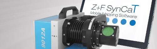
Description
With the software Z+F SynCaT®, Zoller+Fröhlich creates a connection between the Z+F PROFILER® 9012 and external positioning and navigation systems. SynCaT stands for synchronization, calibration and transformation - also representing the main tasks of the software. Z+F SynCat® includes all the features below: Calibration: Processing of calibration parameters due to different system integrations (translation, rotation offsets between the coordinate systems of the navigation-unit (trajectory) and the Z+F PROFILER® 9012 laser scanner) Synchronization: Synchronize Z+F PROFILER® 9012 laser scanner data with trajectory data and generate 3D point cloud files Transformation: Transform 3D point cloud data to different local coordinate systems and apply different local/global height correction models (geoid correction files) Correction: Individual offset estimation referring to predefined ground control points (GCP’s) Z+F SynCaT® is a modular structured mobile mapping software.
- 3D scanner
- Mapping software
- Mobile Mapping
- Z+F SynCaT
Similar products from ZOLLER & FRÖHLICH GMBH
ZOLLER & FRÖHLICH GMBH
Germany

Highly accurate measurement results require static scans from multiple angles, whereas mobile solutions focus on efficiency. The Z+F FlexScan® platform developed by Zoller + Fröhlich combines the advantages of static scans with the efficiency of mobile systems. The perfect complement for any time-sensitive or large-scale application: AEC, facilitiy management, process industries, heritage documentation and forensics. + Universal mounting The Z+F FlexScan® 22 is highly versatile and can be easily used with various support systems. This SLAM platform can be attached to backpacks, tripod carts, fixed tripods, and robots. Thanks to the Quick Mount System, switching between support systems can be done in just a few minutes. Furthermore, data captured with different support systems can be effortlessly registered in Z+F LaserControl®.
ZOLLER & FRÖHLICH GMBH
Germany
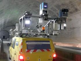
Zoller + Fröhlich has developed the Z+F PROFILER® 9012 and the Z+F PROFILER® 9020 laser scanners for mobile mapping applications, which can be flexibly integrated into the mobile mapping systems of almost all MMS providers. Railway applications on vehicle (train, etc.) and trolley platform Light space applications, for the inventory of tunnel tubes (railway and road), vegetation, signs and safety corridors Road applications (MMS) for road maintenance, traffic infrastructure detection, and general object acquisition Because of the high data capture rate, Z+F laser scanners operate accurately even from mobile platforms, at speeds of up to 120 km/h (approx. 75mph).
ZOLLER & FRÖHLICH GMBH
Germany
Scantra® is a programme for automated registration of point clouds captured by terrestrial laser scanners based on identical planes and points. It has been designed to process very large projects with hundreds to thousands of scans with superior accuracy way beyond the error-budget of ICP-based solutions. Typical fields of application are as-built documentation, construction site monitoring or deformation measurement. Scantra is the only software on the market that satisfies established demands from Geodetic Engineering by delivering extensive and meaningful quality measures which stem from a high-performance Block Adjustment. Scantra is capable to handle highly redundant registrations as a consequence of loop-closure constraints yielding in reliable results. Be a part of our net - your advantages at a glance
ZOLLER & FRÖHLICH GMBH
Germany
THE POWERFUL PROCESSING SOFTWARE FOR LIDAR DATA Import, process and manage your LiDAR data from terrestrial, handheld, mobile, airborne laser scanners and easily integrate UAV and 3D imaging data in a single platform. Thanks to the LineUp® Pro technology, automatically align your 3D scans, even without targets! Import point clouds, meshes, CAD models Automatic alignment also without targets Post-processing, analysis and output export